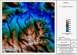
A hypsometric map is map that shows elevation through a color sequence or through shading around the elevation. The resolution of the elevation data can contribute to the overall shading effect that the map has. This is because inbetween two respective contour lines a certain tint or color is given to this area and results in the end product to look as if it were a relief picture. The picture above is a hypsometric map of the Goiania Metropolitan Region. The elevation values range from 700-850 meters so the elevation looks slightly exaggerated at first glance to this map.
No comments:
Post a Comment